

From Cenotes to Sea: Connecting Mexico’s Water Worlds
There Are No Rivers Here
If you arrive in the Yucatán Peninsula looking for a river, you are already looking in the wrong place. In almost any other tropical destination, you would expect to see water flowing over the land. You’d look for valleys carved by rushing streams, waterfalls cascading down mountainsides, or broad deltas feeding into the ocean. But here, the landscape is deceptively flat and incredibly dry. When the tropical rains hit the jungle floor, the water doesn’t pool; it vanishes.
It pulls a disappearing act that has confused travellers for centuries. But the water hasn’t left. It has simply gone underground.
This is the first mental shift required to understand this part of Mexico. What appears to be a scattering of isolated swimming holes, the famous cenotes, is actually the visible tip of a hidden, subterranean vascular system. We aren't dealing with a series of ponds; we are standing on top of one of the largest karst aquifer systems on Earth.
The jungle floor isn’t a barrier; it’s a sieve. And to truly understand what you are swimming in, you have to look beneath the surface.
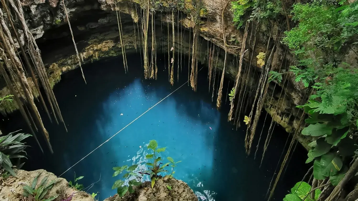
A view from the jungle floor down into a cenote. Photo: Ruben Hanssen
In Short
Here is the big picture of the Yucatán’s hidden water world:
The Hidden Network: There are no surface rivers in the Yucatán; instead, a massive subterranean aquifer system moves water through a limestone "sponge."
The Asteroid Connection: The Chicxulub meteor impact 66 million years ago fractured the Earth, hastening the creation of the famous "Ring of Cenotes."
Windows, Not Ponds: A cenote isn’t an isolated pool; it’s an entrance to a vast, interconnected highway that flows toward the ocean.
The Halocline: You can see where fresh and saltwater meet. A shimmering, blurry boundary that creates a surreal visual effect for divers and snorkelers.
A Single System: The health of the Caribbean coral reefs depends on the health of the cenotes miles inland. What happens in the jungle eventually reaches the sea.
A Landscape Shaped by Stone, Water… and an Asteroid
To understand why the Yucatán functions like a giant sponge, we just need to look at the geology. The entire peninsula is a massive platform of karst limestone. Think of it as a solidified coral reef raised from the seabed millions of years ago.
Limestone is porous. It’also soluble. Over aeons, slightly acidic rainwater has eaten away at the bedrock, dissolving it like sugar in hot tea. Instead of carving valleys on the surface, the water carved caves beneath it.
When the ceiling of one of these underground caves becomes too thin to support the weight of the jungle above, it collapses. The result is a sinkhole, or cenote (which comes from the Mayan word dzonot).
The Chicxulub Connection
While erosion did the slow work, a cataclysmic event provided a crucial structural head start. Approximately 66 million years ago, an asteroid roughly 10 kilometres wide struck the northern Yucatán, creating what is now known as the Chicxulub crater. While this impact is most famous for being generally accepted as leading to the extinction of the dinosaurs, it did something else.
The impact fractured the limestone bedrock along the crater’s rim, a feature now traced by the famous “Ring of Cenotes.” These fractures didn’t create the cave systems on their own, but they introduced zones of weakness that water later exploited, accelerating dissolution and dictating where many cenotes would eventually form.
Cenotes Are Not Isolated Pools
The most common misconception travellers have is thinking of a cenote as a “natural pool”. It looks like one, so the assumption is fair. But unlike a pond, which is a closed, static system, a cenote is an opening into a moving body of groundwater. The water you see is passing through, not sitting still.
A cenote isn’t the destination of the water; it’s a point of access.
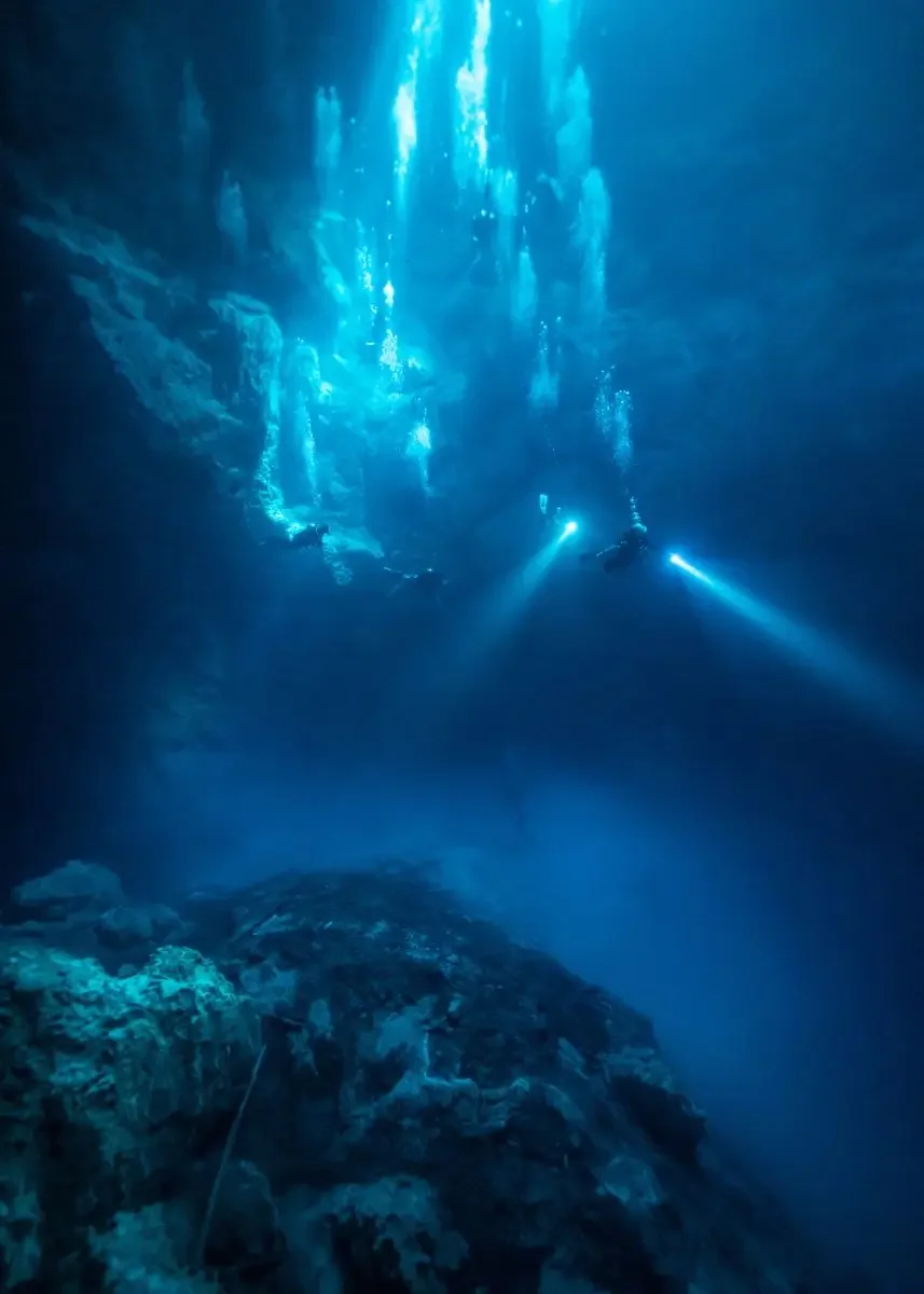
Divers descend into crystal clear water in The Pit Cenote in Yacatan Mexico. Photo: Luke Coley
What a Cenote Actually Is
A cenote is a collapsed sinkhole that exposes the groundwater table below the surface. Some are wide, open-air cylinders; others are caverns with only a narrow skylight. Some begin as little more than a crack in the limestone before opening into vast submerged chambers.
Despite their variety, they all serve the same function: they provide access to the underlying aquifer that stores and slowly transports the peninsula’s freshwater.
Why the Water Is So Clear
One of the first things you notice when snorkelling or diving in a cenote is the visibility. It is often described as "flying" because the water is so clear that it feels almost nonexistent. This clarity exists because there is almost no surface runoff. In a normal river, rain drags soil, silt, and leaves into the current, turning it brown. Here, the limestone acts as a massive filtration system.
But there is a "time depth" to this clarity that adds an extra layer to the experience. The water you are swimming in today likely didn’t fall as rain this morning, or even this week. It may have filtered through the rock for years, or even decades, before reaching the chamber you are exploring. You are quite literally bathing in the past.
But this apparent emptiness is deceptive. The aquifer hosts specialised life adapted to total darkness - blind fish, shrimp, and microscopic organisms found nowhere else on Earth. These species survive in a delicate chemical balance, which is why even small changes in water quality can have outsized effects. The clarity that makes cenotes beautiful is the same fragility that makes them vulnerable.
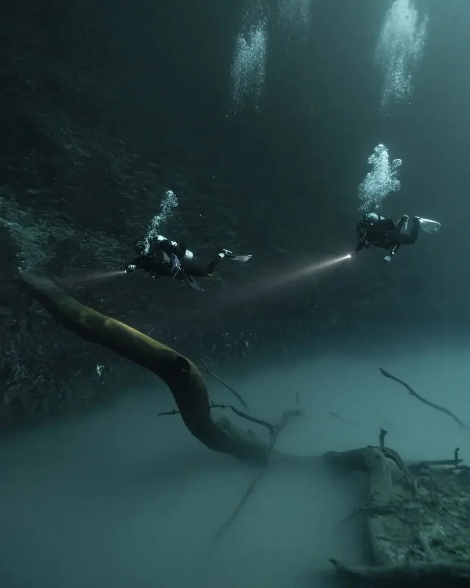
Divers cruising over a hydrogen sulphide cloud in a cenote in Mexico. Photo: Luke Coley
Freshwater Meets the Sea: The Halocline
The halocline is one of the clearest signs that these inland waters are connected to the sea. Not through a single tunnel, but through the permeability of the rock itself. Seawater seeps inland beneath the freshwater lens, creating a layered system wherever the two meet. This interface is visible, tangible, and dynamic, responding to tides, rainfall, and seasonal changes.
They do not exist in all cenotes, but for divers finding them, passing through a halocline is a psychedelic experience. The water creates a shimmering, oily visual effect, blurring your vision as if looking through heat haze on a highway. It is the physical manifestation of two worlds colliding. Even snorkellers can often see this separation from the surface, a ghostly floor where the water chemistry changes.
Underground Highways Beneath the Jungle
Beneath the jungle floor, systems like Sac Actun and Ox Bel Ha stretch for hundreds of kilometres. These aren’t underground rivers in the surface sense; there are no crazy currents here - but they are active conduits.
The water is on a journey, but it moves more slowly than you might imagine. Often it will progress only centimetres per day, migrating from the centre of the peninsula toward the coast through fractures, tunnels, and porous rock. When we swim or dive in a cenote, we are entering a river measured in geological time rather than by its speed.
Not every cave system connects directly to every other, but chemically and hydraulically, they influence one another through the surrounding limestone. Together, they form a single regional aquifer that ultimately discharges toward the coast. Freshwater exits the peninsula through coastal springs, wetlands, and submarine seeps on the seafloor, where it mixes with seawater and influences nearshore ecosystems.
The Overlooked Middle: Wetlands, Canals, and Mangroves
You’ll find plenty of articles on both the cenotes and white sand beaches of Yucatán. But the water doesn’t teleport magically from the cenotes to the ocean.
Before the underground rivers reach the open ocean, the water often surfaces in coastal wetlands, lagoons, and mangrove forests. The Sian Ka’an Biosphere Reserve (a UNESCO World Heritage site) is the prime example of this "middle world."
Here, the water rises to create vast lagoons connected by ancient canals. Interestingly, the Maya didn’t just worship this water; they managed it. The canals found in places like Muyil were dredged and maintained by the ancient Maya to facilitate trade and transport. They were the hydraulic engineers of their time, utilising the natural flow of the aquifer to move goods from the jungle to the coast.
These wetlands act as the final kidney of the system. The mangroves filter out nutrients and sediments, ensuring that the water flowing out to the reef is clean and clear. Without these swamps and mangroves, the coral reefs would suffocate.
The Sea Is Part of the Same System
Finally, the journey ends at the Mesoamerican Barrier Reef, the second-largest reef system in the world. But the connection implies consequences.
Freshwater exits the peninsula through "submarine springs" (known locally as ojos de agua) that bubble up through the ocean floor, sometimes miles offshore. This influx of fresh, cool water regulates the temperature and salinity of the coastal environment, directly influencing the health of coral, seagrass, and fisheries.
This interconnectivity is why responsible travel is so vital.
• The sunscreen that washes off a tourist’s skin in a cenote 50 miles inland doesn’t stay there. It flows downstream, eventually reaching the delicate coral polyps of the reef. Hence the ban!
• Wastewater from rapidly developing towns, if not treated, will flow into the porous ground and poison the very wells that support the tourism industry.
When we say "everything is connected," it isn't a spiritual platitude. It is a hydrological fact. The health of the reef here starts in the middle of the jungle.
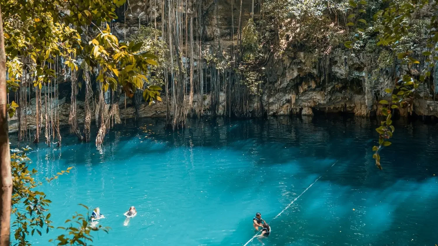
The into a cenote with access for swimming in the Yucatán. Photo: Ruben Hanssen
Why Understanding This Changes How You Experience Cenotes
So, why does a geology lesson matter to someone who just wants a nice swim?
Because context changes perception. When you understand the system, a cenote stops being just a pretty background for an Instagram photo and becomes a trailhead. It becomes a navigation point in a much larger environment.
The Sound of Silence
Understanding the nature of these spaces changes how you listen. In a semi-open cenote or a cavern zone, the acoustics are unique. The limestone absorbs sound, creating a profound, heavy silence, broken only by the rhythmic drip-drip-drip of water falling from stalactites. You’re hearing a process that builds the cave decoration millimetre by millimetre over thousands of years. It creates an atmosphere that demands a hushed reverence.
A Trailhead for Everyone
You do not need to be a technical cave diver with twin tanks and bailouts to appreciate this connectivity.
For the Swimmer: You are floating in rainwater filtered by miles of rock.
For the Snorkeller: You can witness the light beams piercing the darkness, illuminating chambers that were dry during the last Ice Age.
For the Diver: You are moving through the arteries of the planet, hovering between fresh and saltwater.
Knowing that the water around you is on a journey to the sea adds a layer of significance to every stroke. It transforms a passive activity into an act of exploration.
From Curiosity to Experience
The Yucatán is not a place you simply look at; it is a place you enter. Whether you are floating on the surface of a jungle sinkhole, navigating the mangrove canals of Sian Ka’an, or diving the cavern zones where the light plays tricks on your eyes, you are participating in a massive, living cycle.
At Pixel Expeditions, we treat cenotes as more than just attractions. We view them as the entry points to the region’s history, geology, and future. We believe that the best way to protect these systems is to help people understand them, not through lectures, but through immersion.
If you want to experience the cenotes as part of a living system rather than just a checklist item, we are ready to guide you. Whether you are a diver looking to thread the needle of the halocline or a non-diver eager to explore the hidden wetlands and open-air basins, there is a path for you.
Frequently Asked Questions
Are cenotes filled with freshwater or saltwater?
Cenotes are typically filled with freshwater from rainwater that has filtered slowly through the limestone bedrock. However, because the entire Yucatán Peninsula is a porous platform connected to the Caribbean Sea, some cenotes, especially those closer to the coast and the deeper cavern systems, have a layer of saltwater at the bottom.
The denser, warmer saltwater seeps in from the ocean, creating a distinct, visible boundary layer called a halocline. So, in deeper cenotes, you are technically floating in a two-layered water system.
What is a Halocline, and why does it look blurry when diving or snorkelling?
The Halocline is a layer where two bodies of water with different salinities meet and briefly separate. In cenotes where seawater enters, this is the boundary where the fresh rainwater sits directly on top of the heavier, denser ocean saltwater.
When you dive or swim near this layer, the visible blurring and shimmering effect is due to light refraction. The light bends unpredictably as it passes through the rapidly changing density of the water, creating a surreal, mirage-like appearance. It's a natural phenomenon that serves as definitive proof that the cenotes are connected to the sea.
Does the water in cenotes connect to the ocean and the coral reefs?
Yes, absolutely. This is the defining feature of the Yucatán’s hydrology. The cenotes are the exposed access points to one of the largest karst aquifer systems on Earth. This entire system acts as the plumbing for the peninsula, slowly moving freshwater from inland areas toward the coast.
This water eventually emerges through submarine springs offshore, directly feeding and influencing the nearby Mesoamerican Barrier Reef. This connectivity is why responsible travel practices are so important, as any pollution or chemicals introduced inland will ultimately impact the health of the coral reefs and the coastal ecosystems.
Why is sunscreen often prohibited, and what should I use instead?
Sunscreen is prohibited in cenotes because of, among other things, the direct connection between the cenotes and the ocean reefs.
Most commercial sunscreens contain chemicals, including oxybenzone and octinoxate, which are toxic to coral and aquatic life. Even in small amounts, these chemicals can contribute to coral bleaching, disrupt marine ecosystems, and harm the unique organisms living in the cenotes.
We enforce the sunscreen ban before entering the water. The best alternative is to wear a rash guard or UV-protective clothing (long sleeves are ideal).
Are all cenotes part of one single underground cave system?
Not exactly, but they are part of the same regional groundwater system. The Yucatán Peninsula sits on a vast karst aquifer made of porous limestone. Within this aquifer are many flooded cave systems, some directly connected to each other, others separated by rock but still hydraulically linked through fractures and pores in the limestone.
So while there isn’t one continuous tunnel running beneath the jungle, the water itself is part of an open, interconnected system that slowly moves from inland areas toward the coast and the Caribbean Sea. This shared aquifer is what allows water, nutrients, and unfortunately pollutants to travel across large distances underground. In short, many cave systems, one dominant aquifer, and a lot of connectivity in between.
Pixel Expeditions: Quick Guide to Responsible Cenote Travel
Sunscreen: Even "biodegradable" sunscreens can damage the fragile chemistry of a cenote. The best policy is no sunscreen until you are out of the water, wherever you are. Wear a rash guard or UV shirt instead.
Touch: Stalactites and stalagmites are formed by mineral deposits. The oils from human skin stop this growth and break the formation. Look, but don't touch.
Showers: Always rinse off at the provided showers before entering a cenote to remove lotions, bug spray, and perfumes.